Scalable MMRV isn't just about reach, it's about fit.
Perennial delivers end-to-end MMRV across croplands and grazing lands worldwide, with no crop or region out of bounds.
Doing so doesn’t only require the technical capability to measure, monitor, report, and verify (MMRV) anywhere — it requires the flexibility to adapt our approach based on data availability, methodology requirements, land use types, and on-the-ground realities.
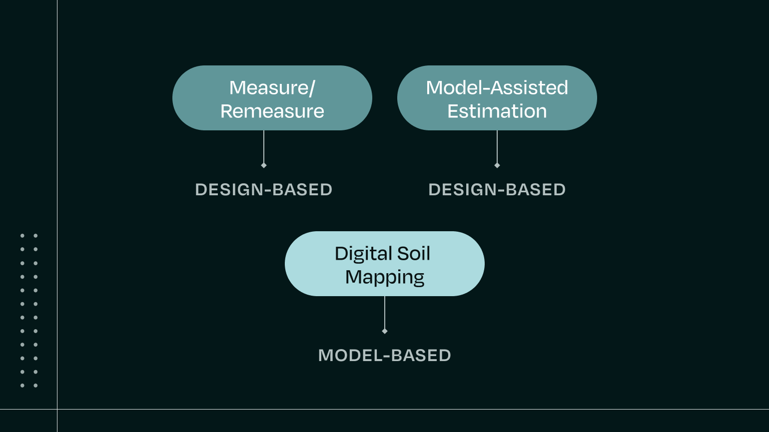
In many cases, digital soil mapping is the best fit — it’s the low-sample, low-cost, low-uncertainty option that can scale to new geographies and crops. But sometimes a project is better served by combining digital soil mapping with a biogeochemical model and sometimes it’s actually best to start with a traditional measure–remeasure approach.
We’re committed to choosing the monitoring approach that’s best suited for each project and to optimizing every step of the MMRV process, regardless of the approach — reducing sampling, lowering uncertainty, and improving outcomes along the way.
Below we'll unpack three monitoring approaches, when we'd recommend them, how we add value to each of them, and the shared foundation that optimizes every project from the beginning.

An optimized foundation for all projects
Since every monitoring method we use is rooted in robust ground truth measurements, each Perennial project begins the same way: with intelligent planning, stratification, and sampling design.
This foundation sets projects up for success from day one:
- Digitization & field cleanup: We use our Digital Twin platform to digitize the project and clean up boundaries with our Field Boundary Editor, ensuring clean, accurate field data from the start.
- Field prospecting: Our Field Prospecting tool enables you to compare SOC sequestration potential across and within fields — so you can prioritize regenerative interventions where they’ll have the greatest impact and ROI.
- Stratification & Sampling: Our Smart Stratification tool uses advanced data and statistical analysis to pinpoint the best sites for sampling, reducing within-stratum variability while maximizing statistical strength. This not only reduces the number of samples needed, it also helps lower uncertainty.
We can also coordinate logistics for soil sampling — tapping trusted local teams to collect samples on your behalf, or collaborating with your preferred sampling provider.
Before monitoring begins, we’ve already helped:
- Digitize the project, avoiding costly, manual record-keeping
- Optimize outcomes by identifying high-potential land
- Reduce the number of samples required
- Lower uncertainty
Digital soil mapping

What is digital soil mapping?
Digital soil mapping uses soil samples, machine learning, and biogeochemically-informed predictors to quantify soil organic carbon (SOC) at scale.
Perennial’s proprietary model, ATLAS-SOC, has been trained on more than 350,000 soil samples, peer-reviewed, and validated by third parties. It enables us to quantify SOC across regions, crop types, and land uses with high accuracy and low uncertainty — even in areas where traditional models don’t apply.
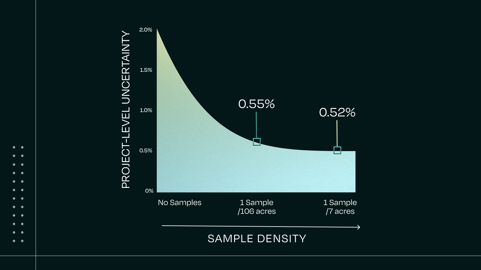
When localized with soil samples, ATLAS-SOC Fine-tuned can deliver >95% accuracy and <5% uncertainty — and it requires up to 10x fewer samples than traditional monitoring approaches.
Perennial is leading the development of CN0137— a Verra tool for quantifying organic carbon stocks using digital soil mapping as a standalone technology or in conjunction with biogeochemical modeling.
As Verra put it, digital soil mapping “is critical to reducing the costs associated with the implementation and scaling up of Agricultural Land Management (ALM) projects. Compared with traditional soil sampling methods, digital soil mapping allows for broader spatial coverage, improved spatial resolution and precision, and increased cost-effectiveness, among other benefits.”
How it works
Our ATLAS-SOC model uses samples to train a model that predicts SOC for every pixel in your project. Essentially, it fills in the gaps between and around your soil samples, resulting in up to 100x more SOC estimates compared to sampling alone.
We then calculate uncertainty for every pixel, field, and portfolio. This reduces uncertainty significantly — even compared to models with more samples but fewer total predictions.

When is Digital Soil Mapping the best approach?
Digital soil mapping is often the most efficient and cost-effective path forward for:
- Fixed-baseline methodologies like VM0032 or GHG Protocol
- Scope 3 sustainability initiatives
- Projects in regions with no registry-approved biogeochemical model
- Projects with crop types with no registry-approved biogeochemical model
- Projects currently using measure–remeasure looking to reduce sampling and uncertainty
- For VM0042 and other intervention-based methodologies, see below how digital soil mapping can pair with biogeochemical models for optimal outcomes
Digital soil mapping + biogeochemical model
What are biogeochemical models?
Biogeochemical models (BGCMs) simulate SOC dynamics over time based on farm practice inputs, soil properties, microbial activity, and climate conditions. Many BGCMs also estimate N₂O and CH₄ emissions, though some focus on carbon only. They are commonly used to generate dynamic baselines or counterfactual scenarios and are required in methodologies like Verra’s VM0042.
Challenges and limitations of biogeochemical models
Standalone BGCMs require years of input data and dense sampling to generate defensible results. They can be difficult or impossible to deploy in regions where models haven’t been validated — and even where they are, high cost and complexity remain barriers.
How Perennial improves biogeochemical model workflows
By using our ATLAS-SOC Fine-Tuned SOC outputs to directly initialize a BGCM, we enhance BGCM workflows by enabling better results with fewer samples.
- Intelligent Planning & Stratification: We reduce the number of samples needed and improve data consistency
- ATLAS-SOC Fine-tuned: We fill in spatial gaps between samples, increasing the data input density
- Pixel-level uncertainty modeling: Between the increased data inputs and modeling uncertainty for each pixel, we’re able to lower project-level uncertainty, which can result in a lower uncertainty deductions and thus more saleable credits for project developers.

When to use a hybrid digital soil mapping + biogeochemical model approach
We recommend combining Perennial’s digital soil mapping with a biogeochemical model when:
- You’re already using a BGCM and want to reduce sampling, reduce costs, and improve both outcomes and uncertainty
- A dynamic baseline is required under your selected methodology
- Your region, crop, and intervention type are already supported by an approved BGCM (e.g., RothC, DayCent)
- Your regenerative practices began before your first round of sampling — and you want to recognize and reward those early years through credit issuance
Measure–remeasure
What is measure-remeasure?
Measure–remeasure is the most direct approach to MRV: sample now, sample later, and calculate the difference. It doesn’t require modeling and is compliant with many inventory-based carbon protocols.
When to use measure-remeasure
We recommend starting with measure–remeasure when:
- Your region, crop, or practice is too new for digital soil mapping or biogeochemical models (e.g. biostimulants and novel inputs, tree crops in under-studied regions, etc.)
- There’s insufficient local data to train or run a model
- The project is early-stage and needs a compliant baseline quickly
- You have the ability to create and manage baseline control areas
Challenges and limitations
This approach comes with the highest sampling requirement — often 10x more than Perennial’s digital soil mapping approach — which increases costs and operational complexity, particularly for dispersed or smallholder projects.
How Perennial improves measure-remeasure workflows
Even in sample-only projects, we use our intelligent planning and stratification tools to reduce sampling burden and streamline logistics. We perform the same rigorous calculations of SOC changes, uncertainties, and end-to-end auditability all in one place — with verifier-ready documentation and traceability.
We also apply strict QA/QC across the entire sampling workflow — from validating SOPs used by sampling partners and labs to catching issues like labeling errors, analytical anomalies, or inconsistencies across strata. This hands-on oversight helps ensure data integrity and improves confidence in project results.
Plus, every measurement event helps build a dataset that can later power digital soil mapping. Over time, we can shift projects from sample-only MRV to a digital soil mapping approach, preserving compliance while lowering cost and complexity.
Transitioning from measure–remeasure to digital soil mapping
For projects already doing measure–remeasure, moving to digital soil mapping is a major unlock: it makes the most of your existing samples, reduces future sampling, lowers uncertainty, and may increase saleable credit volume.
Perennial’s ATLAS-SOC Fine-tuned model generates up to 100x more SOC estimates compared to sampling alone. That denser dataset, combined with pixel-level uncertainty modeling, allows us to dramatically increase measurement coverage — even with 10x fewer samples.
This can lead to lower uncertainty deductions when it comes time to report, simply by applying ATLAS-SOC on top of your existing project data.

Not one-sized-fits-all but one provider
Our goal isn’t to fit every project into the same monitoring framework. It’s to recommend and deliver the right approach — and to improve outcomes for all projects, regardless of region, methodology, crop, or land use.
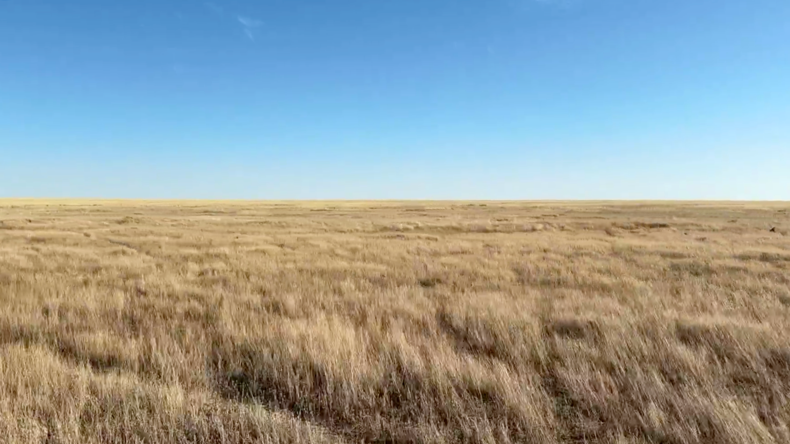
Whether you're working in a highly modeled landscape, like the croplands in Île-de-France, or launching a program in an underrepresented region, like the grasslands in Kazakhstan, we can support your MMRV needs end-to-end, from planning through to issuance or reporting.
MMRV is not one-size-fits-all. But you can do it all with Perennial.
_____
Have questions or exploring MMRV options for your project?
Reach out to our team — we’re here to help you find the best fit for your specific project and goals.