


Ask ten people in carbon markets what digital soil mapping is and you'll get answers ranging from "satellites measuring soil carbon" to "a model that fills in the blanks". The first is wrong and the second is incomplete, and the gap between a wrong answer and a half answer is why the conversation about whether DSM belongs in a methodology keeps stalling. Here is what it actually is, and what matters when you're assessing one.
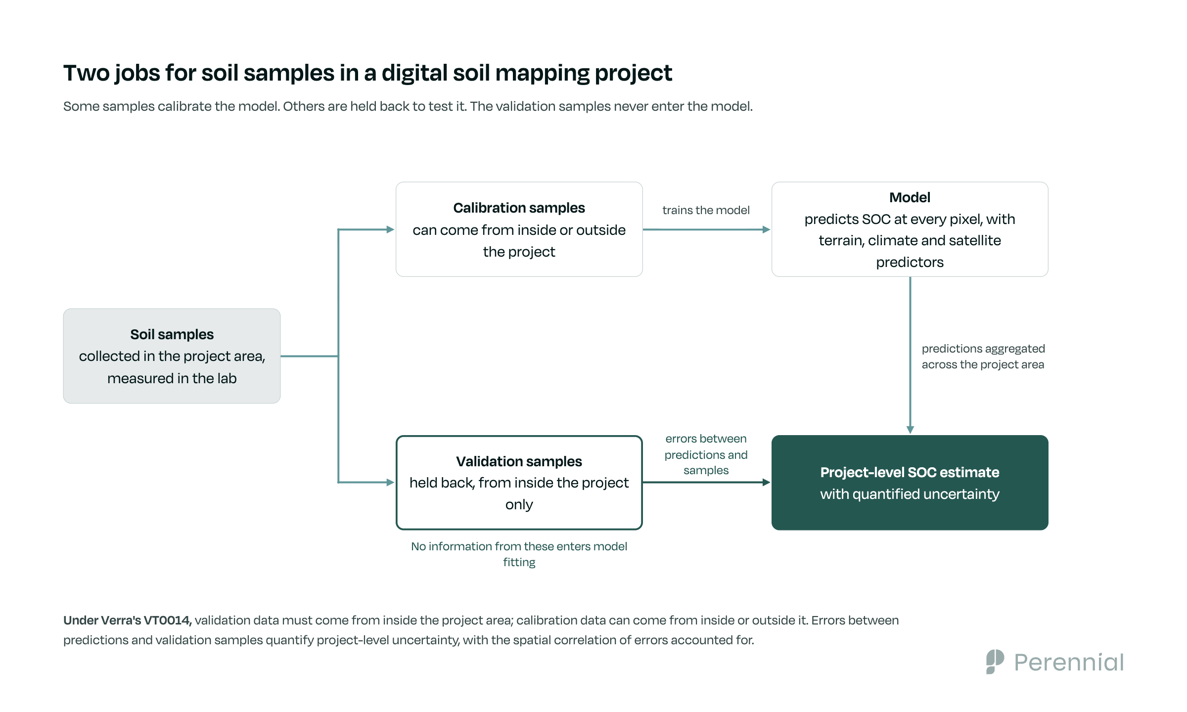
Digital soil mapping starts with soil cores, which is not where most people expect it to start. For carbon MRV, DSM still depends on physical soil measurements. Soil samples provide observations for model development and, critically, independent validation against the project area. The exact collection and laboratory methods depend on the applicable methodology. Nothing about DSM removes the sampling step, and anyone who tells you it does is describing something else.
What changes is the job those samples do. In a conventional sampling program the samples carry the estimate: you measure a set of locations, average them, and that average stands in for the project, carrying the error that comes with representing a large area through a small number of points. Under DSM, soil samples play several roles: some support calibration, independent measurements test whether the model performs on the project area, and validation errors are used to quantify uncertainty when predictions are aggregated across space. The model then produces an estimate at every location in the project area. A project with a few thousand physical samples across 100,000 hectares ends up with more than a million SOC predictions across the same ground, one per pixel. Depending on the quantification pathway, those predictions can replace direct measurements as SOC inputs to subsequent calculations, but their prediction uncertainty has to travel with them.
Project-level uncertainty falls with the area you aggregate over, not with the number of pixels you count
Individual DSM predictions carry prediction uncertainty. A physical SOC stock observation carries uncertainties of its own too, from field sampling, laboratory analysis, bulk density, gravel and depth corrections, depending on the workflow. So comparing one pixel with one core settles very little, and it is also the wrong comparison, because projects aren't credited one pixel at a time.
They're credited on the project-level estimate.
When predictions are aggregated over a sufficiently large area, uncertainty in the estimated project-wide mean can fall substantially. But pixels are spatially correlated, so they cannot be treated as millions of independent measurements: the covariance structure of prediction errors has to be explicitly accounted for, and VT0014 requires exactly that when estimating uncertainty in the area-wide mean. Adding raster resolution on its own does not reduce uncertainty.
Perennial's published simulations and validation studies show that project scale can materially reduce uncertainty in the area-wide mean, sometimes enough that relatively sparse sampling still produces low project-level uncertainty. The effect depends on model performance, project area and the spatial correlation of prediction errors. This tells you where to look. "How many samples did they take?" is not enough on its own. The more useful questions are what those samples were used for, whether the validation evidence is independent and representative, and whether the resulting uncertainty is defensible.
A new region raises per-pixel error, and what VT0014 requires there is local validation, not local calibration
The obvious objection: fine for Iowa with its decades of soil data, but what about ground nobody has mapped?
Less data in a region does mean higher per-pixel error, and that is a real constraint rather than a presentational one. Whether it also means higher project-level uncertainty depends on project area and the spatial structure of the errors, as above. It doesn't mean a model trained elsewhere can be pointed at new ground and left to it. What Verra's VT0014 does require is local evidence that the model works: validation data must come from within the project area. Calibration data can come from inside or outside the project area, but the resulting model still has to pass outcome-based validation against independent local measurements.
That distinction decides more than it looks like it does. It separates a method that only works where data is already abundant from one that reaches the places carbon finance has historically skipped, and what determines which you're dealing with is the validation protocol, not the familiarity of the region.
Verra has already written down what a standard needs to specify
VT0014, approved for quantifying soil carbon stocks using digital soil mapping, sets requirements in three areas: calibration, validation, and uncertainty estimation. It was built over four years with a global expert group and shaped through public consultation, and it is currently approved for use with VM0042 and VM0032 where applicable. Verra notes that it may potentially support other methodologies that quantify agricultural SOC stocks.
Verra's own reasoning is worth repeating, because it is a standard-setter explaining why it took the trouble. Compared with traditional soil sampling methods, it found, DSM allows broader spatial coverage, improved spatial resolution and precision, and increased cost-effectiveness, and it described the approach as critical to reducing the costs of implementing and scaling agricultural land management projects.
Nobody has to copy Verra's answers. The useful part is that the hard questions were worked through in public, which means the next programme to look at DSM doesn't start from a blank page.
Four things worth testing, and sample count alone isn't enough
VT0014 deliberately sets no fixed minimum sample number, but sample count is still reported and assessed: the independent modelling expert has to determine whether the calibration and validation samples are sufficient to pass the model-validation tests and meet the applied methodology. Sample count matters; it just isn't a standalone quality metric.
Start with whether validation is genuinely independent of calibration. A model evaluated on data it was fitted to will report excellent accuracy and tell you nothing. VT0014 permits several validation designs, from fully independent validation sets to leave-one-out, k-fold and geographically dependent cross-validation, but information from the validation observations cannot leak into model fitting or hyperparameter tuning, and how spatial dependence between training and validation points is handled matters as much as the split itself.
Then whether the uncertainty estimate is calibrated rather than merely reported. A model that says it's 90% confident should be right about 90% of the time, and that is testable. Related but separate: whether bias has been quantified apart from error, because a model can be precise and consistently wrong.
Beyond the formal methodology tests, there is one more useful commercial due-diligence question: has the model performed on data the provider did not control? Perennial's model was evaluated against more than 5,200 independent samples in peer-reviewed work, and separately in blind validation with Bayer, where predictions were made before any local samples changed hands.
Where Perennial fits
Perennial led the development of VT0014 and works with project developers, standards and registries on what sound DSM practice looks like inside a methodology: calibration and validation design, uncertainty propagation, and the documentation an auditor needs in order to check any of it.
If you're working out where DSM fits in your own programme, we're happy to go through the mechanics, including the parts that are still genuinely open.
Learn more about Perennial's MMRV →
