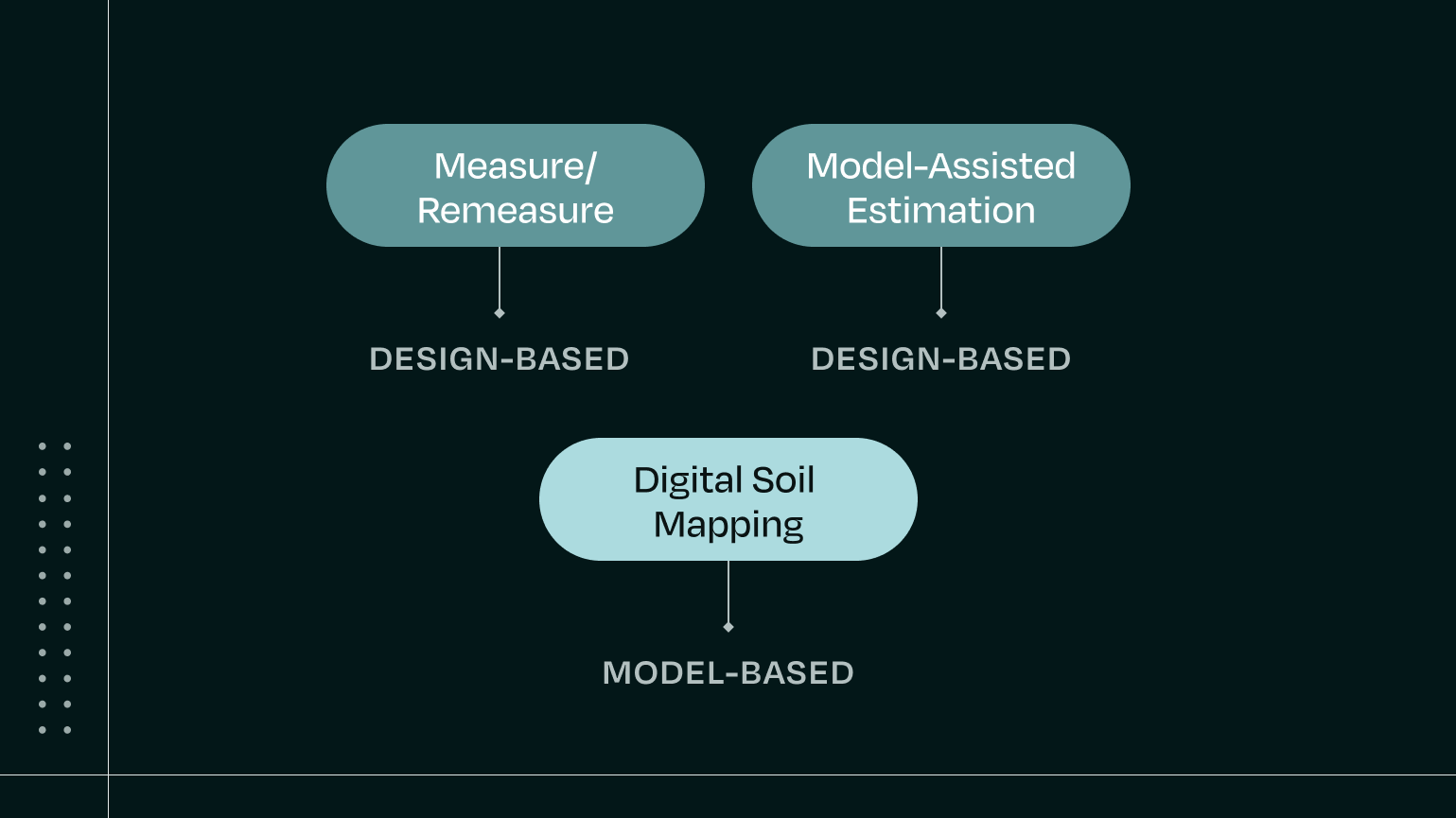
Bayer and Perennial collaborated to evaluate ATLAS-SOC, Perennial’s digital soil mapping model, and its ability to reduce soil sampling while achieving low-uncertainty quantification.
The work began as a blind validation — Bayer shared only field boundaries, holding back thousands of measured soil samples for comparison. Over time, Bayer incrementally released subsets of that data, allowing us to fine-tune the model and observe how accuracy and uncertainty changed with each step.
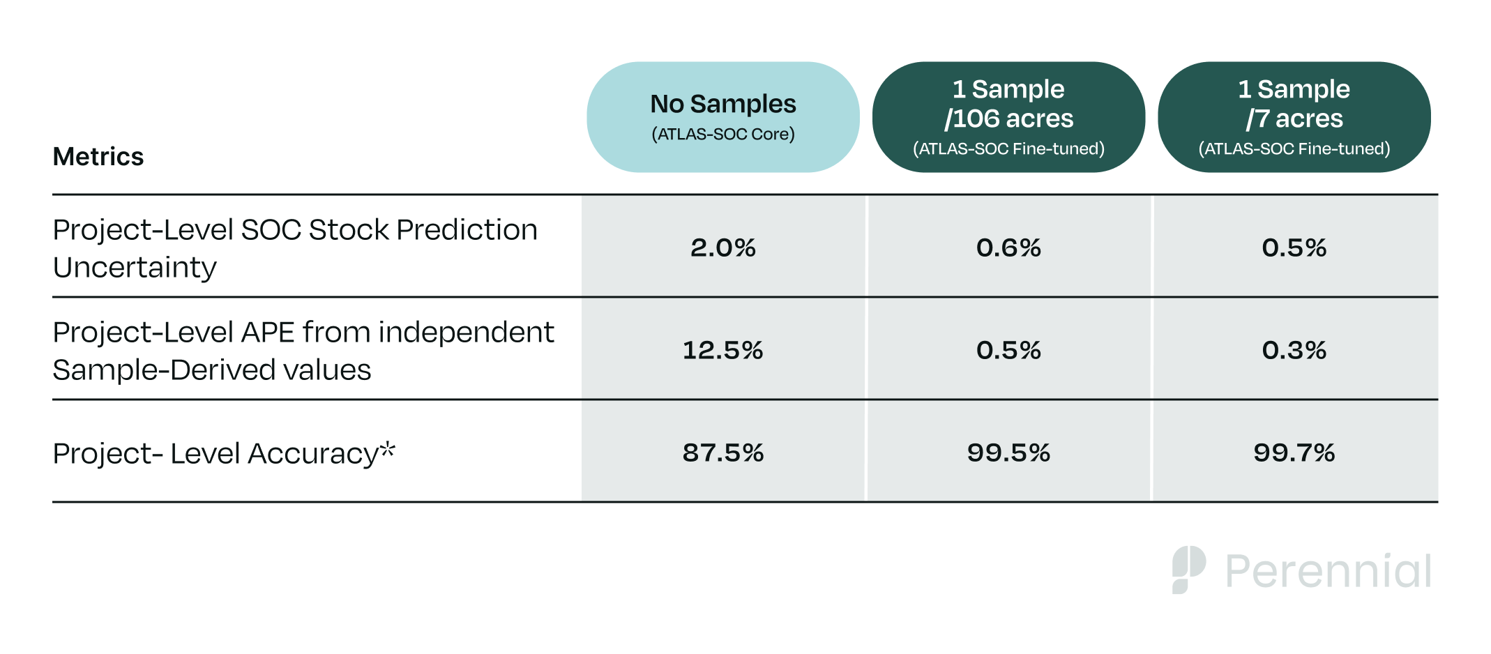
Across two validation phases — first a 700-acre pilot and then a 53,000-acre scale-up — Bayer compared ATLAS-SOC predictions against more than 10,000 measured soil samples. Phase 2 results showed that ATLAS-SOC maintained project-level uncertainty near 0.5% (ranging between 0.52–0.55%) even as sampling density decreased more than 15x, confirming that we do not require intensive sampling to accurately quantify SOC at scale.
.png)
It also showed how our model’s predictions improve as the project area scales; even with sparser sampling, ATLAS-SOC Fine-tuned achieved lower uncertainty in the 53,000-acre project than in the 700-acre pilot.
As Cornelius Streit, VP Global Carbon Operations at Bayer’s Crop Science division, put it:
“This validation study demonstrated that Perennial’s digital soil mapping can make soil carbon quantification far more efficient and less disruptive — reducing the burden of soil sampling, minimizing disturbances for farmers, and lowering program costs.”
Dig into the details below.
Phase 1 — Initial Validation & Testing Accuracy
The initial blind validation study from 2023 covered 39 fields across five Midwestern states, totaling about 700 acres. Bayer held roughly 1,350 ground-truth samples, of which about 250 (≈ 1 per 2.8 acres) were later shared for model calibration.
Perennial first ran ATLAS-SOC Core, our foundational model — which has integrated 350K+ samples globally, but no samples from the Bayer project area. At this stage, the model achieved 1.8% project-level uncertainty, predicting SOC stock within 1.5% of Bayer’s measured mean.
After localizing the model with the limited Bayer sample set (ATLAS-SOC Fine-tuned), uncertainty improved. With 1 sample for every 4.7 acres, project-level uncertainty lowered to 1.2%, matching Bayer’s measured SOC stock within 0.5%. When sampling density was increased (1 sample for every 2.8 acres), uncertainty was improved further, but only slightly; going from 1.2% to 1.1% at the project level.

Takeaways:
ATLAS-SOC reproduced measured SOC stocks fairly accurately, even without local samples and fine-tuning improved precision. Once ATLAS-SOC was fine-tuned on local samples, increasing sample density only led to marginal improvements in uncertainty.
These early results provided Bayer the confidence to expand the evaluation to a larger, more rigorous second phase focused on testing impacts of sample density and scale.
Phase 2 — Testing impacts of sample density and scale
The second validation phase began in 2024 and extended to approximately 53,000 acres across nine U.S. states, incorporating 10,901 post–quality-control soil samples collected by Bayer across roughly 450 fields.
The goal was to test how sampling density affects model accuracy and uncertainty at both field and project levels.
First, Perennial generated predictions using only its foundational model, ATLAS-SOC Core. After running validation analysis on the resulting predictions, Perennial finetuned models on subsets of Bayer’s sample data, at progressively higher densities, re-evaluating uncertainty with each iteration before releasing the next set. Sampling densities tested were 1 sample per every 106, 50, 20, 10, and 7 acres.
Without local samples, ATLAS-SOC Core achieved 2% project-level uncertainty. That dropped to 0.55% when localized with 1 sample for every 106 acres, and to 0.52% when localized with 1 sample for every 7 acres. (Values are rounded to one decimal place in the table below.)
Takeaways:
Across sampling densities that varied more than fifteen-fold, ATLAS-SOC Fine-tuned’s performance remained remarkably consistent, with project-level uncertainty remaining between 0.52% and 0.55%. This confirms that beyond a certain point, collecting additional soil samples yields diminishing returns in improving model performance for a fixed project area. In practice, that threshold depends on cost per sample and other project-specific financial considerations.
A far more influential lever for reducing uncertainty is project scale. In Validation Phase 2, ATLAS-SOC Fine-tuned achieved a lower project-level uncertainty than in Validation Phase 1, despite reducing sampling density more than 37x (1 sample per 106 acres compared to 1 sample per 2.8 acres). While this improvement partially reflects improvements to our model made between 2023 and 2024, the primary driver was the expansion in project area from 700 acres to 53,000 acres. Because digital soil mapping models generate spatially continuous predictions, the effective number of measurements (pixels) increases naturally with project area, and, in turn, uncertainty declines rapidly as the size of the project grows.
“This study helped confirm that ATLAS-SOC performs reliably across a range of sampling densities,” said Christian Clanton, VP of Data Science at Perennial. “We’re continuing to evaluate how far we can safely extend that efficiency — including validation tests at far lower sampling intensities — and innovate to constantly improve model performance to help partners scale soil carbon measurement with confidence.”
Implications for Project Developers
These validation studies demonstrate how Perennial’s digital soil mapping model can meet stringent accuracy requirements and achieve low uncertainty without intensive field sampling.
The results have several practical implications for project developers:
- For project developers currently using dense sampling, there’s a path to reducing sampling — and by extension costs and complexity — all while maintaining or even lowering their uncertainty.
- For project developers using sparse sampling and facing high uncertainty, digital soil mapping can make the most out of their existing samples, enabling them to lower uncertainty — and potentially their uncertainty deduction — without increasing sampling.
Looking Ahead
These validation studies from 2023 and 2024 marked early milestones in an ongoing, multi-year collaboration between Bayer and Perennial. As one of the first major agricultural companies to rigorously evaluate digital soil mapping — beginning years before Verra formally recognized it — Bayer helped shape an early model for scaling credible, data-driven soil carbon measurement.
The findings confirmed that with Perennial’s digital soil mapping model, low-uncertainty quantification can be achieved at scale with far fewer samples than traditional approaches — supporting more efficient, scalable, and cost-effective soil carbon programs.
These validation studies have helped establish the technical foundation as Bayer evaluates how Perennial’s MMRV could be integrated across its global carbon, Scope 3, and sustainability programs.
We look forward to sharing more in the future.