New research suggests uncertainty deductions below 5% for large, long-term carbon projects — advancing the case for digital soil mapping as a precise, scalable, and financially favorable approach to soil carbon MMRV.
Boulder, CO — July 9, 2026 — Perennial, the leading measurement, monitoring, reporting, and verification (MMRV) provider for soil carbon programs, today announced the publication of a new peer-reviewed study presenting its full end-to-end digital soil mapping (DSM) framework for quantifying soil organic carbon (SOC) stock change and uncertainty deductions in the voluntary carbon market.
The study was led by Alexandre Wadoux, PhD, of James Cook University — one of the world's foremost experts in digital soil mapping and geostatistics — in collaboration with Perennial Chief Scientist Jim Kellner, PhD, of Brown University, several Perennial scientists, and scientists working in academia. It is the first peer-reviewed paper to use the methods described in Verra’s VT0014, assessing change over time using digital soil mapping in the context of the voluntary carbon market — including a geostatistically rigorous treatment of uncertainty at the project level.
This is now the third peer-reviewed publication on digital soil mapping from the scientific team at Perennial — the only MMRV company whose digital soil mapping approach has been independently validated through peer review.
Key findings include:
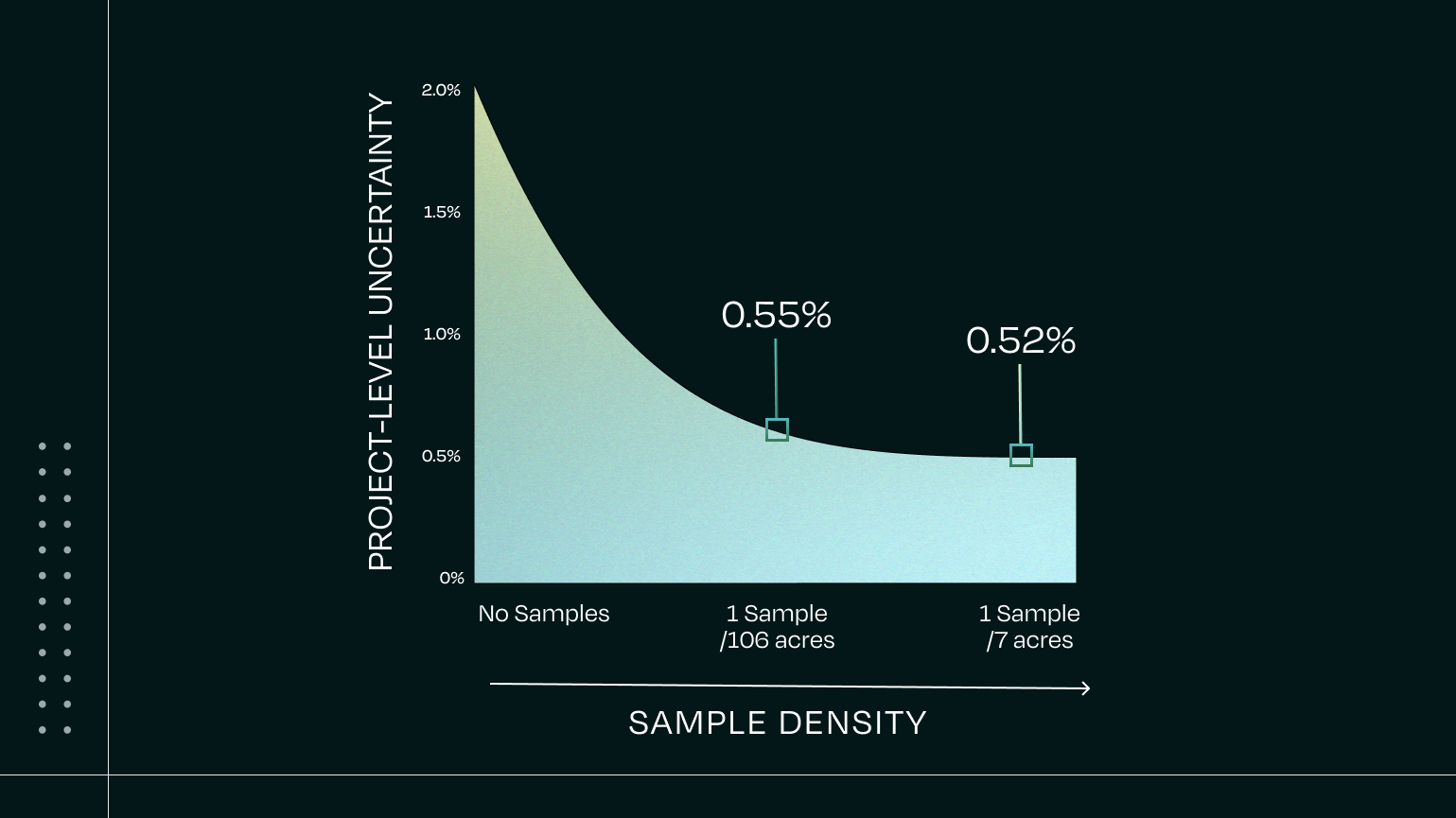
- Accurate project-level estimates across a wide range of sampling densities — mean SOC predictions at the project level remained stable even as the number of calibration samples varied widely.
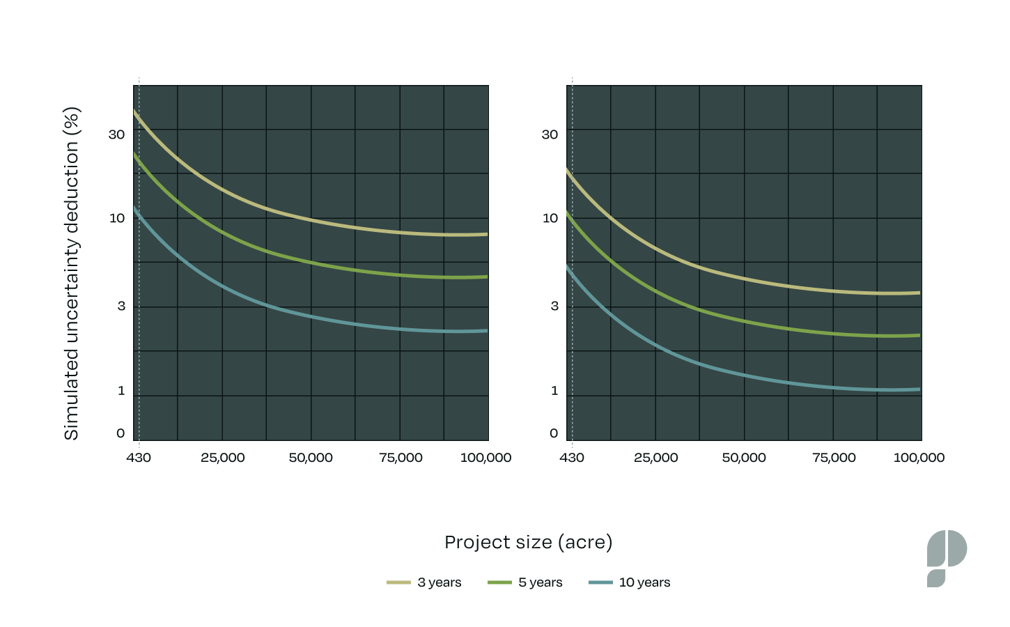
- Simulations showed uncertainty deductions below 10% for most projects exceeding five years, and below 5% for projects greater than 50,000 acres, demonstrating DSM’s ability to achieve low uncertainty deductions at scale.
- In simulated SOC projects, uncertainty decreased with both project size and duration — a spatial averaging effect inherent to model-based approaches that reduces uncertainty without requiring proportional increases in soil sampling.
These findings are notable in the context of a market where major carbon projects have accepted uncertainty deductions of 15% or higher. Because uncertainty deductions are applied directly to the estimated carbon removal when calculating creditable tons, lower deductions mean more of the sequestered carbon translates to saleable credits — improving revenue and project economics for developers.
The study also demonstrates a key relationship between point-in-time quantification precision and change-over-time uncertainty: because the uncertainty of the estimated change is derived from the uncertainties at each measurement event, achieving high precision at a single point in time directly reduces the uncertainty of the change estimate. In other words, precision at baseline compounds into more favorable economics over the life of a project.
"Digital soil mapping has been around for a few decades — we know how to map soil carbon stocks and how to quantify uncertainties at different spatial scales," said Alexandre Wadoux, PhD, lead author and digital soil mapping researcher at James Cook University, formerly at INRAE. "What this paper adds is a complete, peer-reviewed framework for applying that knowledge to carbon markets — including change over time and the uncertainty deductions that determine how many credits a project can generate."
"We publish so that others can understand our methods," said Jim Kellner, PhD, Chief Scientist at Perennial and corresponding author of the study. "Perennial has invested seven years and millions of dollars in research and development to get here. Sharing this research openly, and exposing it to peer review, is how we demonstrate rigor to our customers and the market."
The study's framework is aligned with the Verified Carbon Standard's VT0014 tool that Perennial developed, which enables digital soil mapping to be used for Agricultural Land Management (ALM) methodologies requiring SOC quantification, such as VM0042 and VM0032.
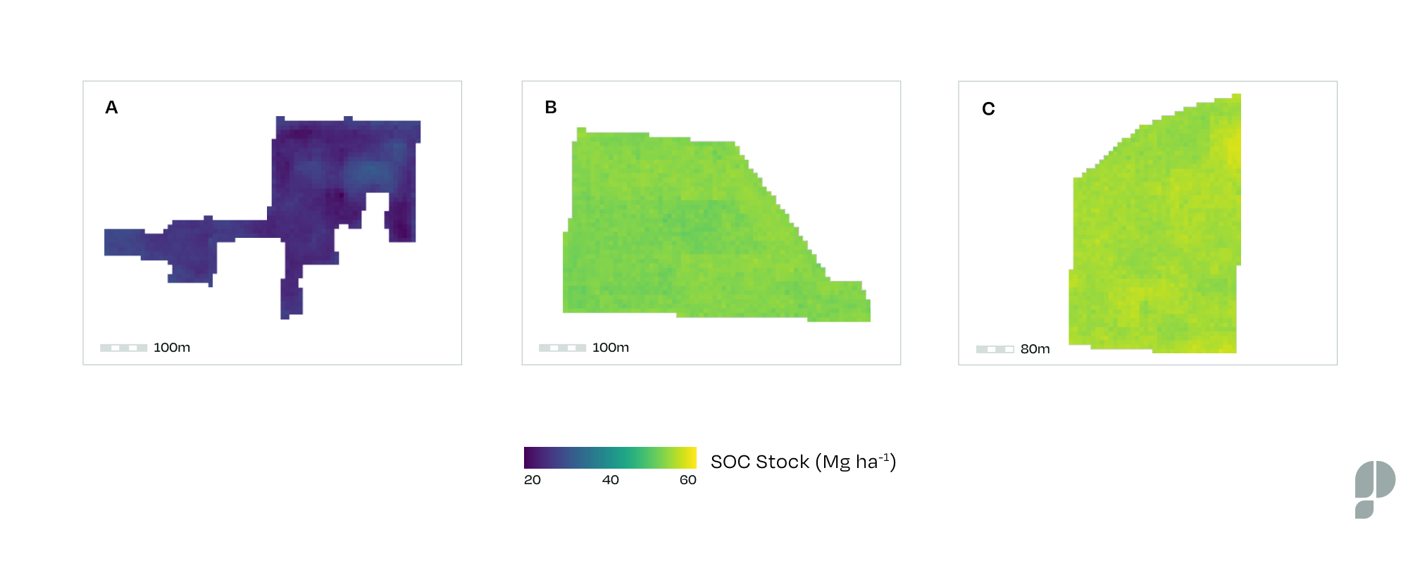
Perennial's ATLAS-SOC model, which underpins the framework demonstrated in the study, leverages a large proprietary database of high-quality soil samples and incorporates nearly 80 environmental covariates — including remote sensing vegetation indices, climate variables, soil properties, and topographic data. It is the only peer-reviewed digital soil mapping application from an MMRV company to date.
The paper is published in npj Sustainable Agriculture and is available at https://www.nature.com/articles/s44264-026-00125-0.
About Perennial
Perennial is an end-to-end MMRV (measurement, monitoring, reporting, and verification) company delivering registry-aligned, outcome-based measurements for any crop, any land use — anywhere in the world. Its advanced digital soil mapping technology drastically reduces sampling needs and eliminates geographical limitations, making it the most cost-effective, scalable way to measure, report, and verify emissions reductions, carbon removal, and sustainable outcomes. Based in Boulder, CO, Perennial has raised $35M+ from investors including GenZero, Microsoft Climate Innovation Fund, Bloomberg, and SineWave Ventures. Learn more at www.perennial.earth.
Media Contact: Heidi Sloane, Director of Marketing, Perennial, press@perennial.earth